
Breaking News
Mostly Clear Tonight
A Passing Shower Early?
Hazy, Hot & Humid Tuesday
Severe Storms are likely


Last Complete Site Update: 7/13 - 3:50 PM
Weather for New England and the Northeast
Updated Twice per day
Delivering Weather Forecasts for New England for 27+ years.
"More than a forecast. RichLefko.com provides in-depth New England weather analysis, climate statistics, rainfall and snowfall tracking, drought monitoring, and enhanced National Weather Service discussions for weather enthusiasts and informed decision-makers."
Just need the daily forecast?
We have that as well.
Active Hazards, Advisories, and/or warnings
Heat Advisories are active across New England for Tuesday-Wednesday
Severe Weather Likely Tuesday - Some storms could become intense, producing damaging winds, large hail, tornadoes, and frequent lightning.
None
If the alert below is flashing, then the warnings/advisories above are active. Use those links to go to that hazard page.


"July, with its days of blue skies and time that seemingly stands still,
holds a special place in my heart." - Daisaku Ikeda
Today’s Weather at a Glance
Updated Every Morning and as Needed Through the Day
(Averages Across Southern NH)
86Degrees
High Temperature
0%
Probability of Precipitation - Daytime
66Degrees
Low Temperature
0%
Probability of Precipitation - Nighttime
Personalize your settings on the panel.
Today in Peterborough, NH at a Glance
Today in Nashua, NH at a Glance
Your Daily Forecast - Three Days at a Time

Heat Advisories are active
Tuesday-Wednesday
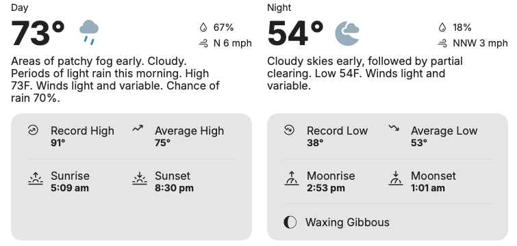
Monday/Monday Night - July 13
Nashua - East


Mostly clear, with a low around 68. Southwest wind around 5 mph.
Peterborough - Central/West
Mostly clear, with a low around 65. Southwest wind around 5 mph.
Tuesday/Tuesday Night - July 14
Nashua - East

Mostly sunny and hot, with a high near 98. Heat index values as high as 104. West wind 5 to 10 mph, with gusts as high as 20 mph.

Partly cloudy, with a low around 75. West wind 5 to 10 mph.
Peterborough - Central/West
Mostly sunny and hot, with a high near 93. Heat index values as high as 97. West wind 5 to 10 mph, with gusts as high as 20 mph.
Mostly clear, with a low around 73. West wind 5 to 10 mph.
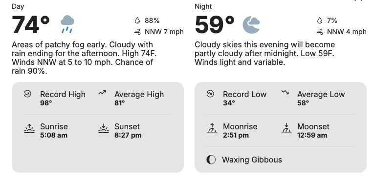
Wednesday/Wednesday Night - July 15
Nashua - East
Mostly sunny and hot, with a high near 93. Northwest wind around 10 mph, with gusts as high as 25 mph.
Mostly clear, with a low around 66.
Peterborough - Central/West

Mostly sunny and hot, with a high near 90. Northwest wind around 10 mph, with gusts as high as 25 mph.
Mostly clear, with a low around 63.
Thursday/Thursday Night - July 16
Nashua - East
Sunny and hot, with a high near 91.

Peterborough - Central/West

Mostly sunny, with a high near 87.
Friday/Friday Night - July 17
Nashua - East
Peterborough - Central/West
Saturday/Saturday Night - July 18
Nashua - East
Peterborough - Central/West
Sunday/Sunday Night - July 19
Nashua - East
Peterborough - Central/West
Current Weather Readings in Peterborough, NH
Time of the readings below: 13 Jul 2026 8:29 PM
(FYI: The number in parentheses is the change in the last hour)
(Note: My weather Instruments are Offline from Midnight Wednesday to 7AM Thursday for system Back ups.)
Current Temperature:
78.4°F (-1.6)
High Temperature:
85.3 at 3:46 PM
Low Temperature:
59.0 at 5:13 AM
Precipitation Today:
0.00 inches
Current Dewpoint:
67.8°F (-2.4)
Highest Heat Index Reading:
88.7 at 3:49 PM
Current Windspeed:
2 MPH (1)
Barometric Trend:
Steady
Hours of Daylight Today:
15:03
Link to my Active Weather Instruments

Information for New England


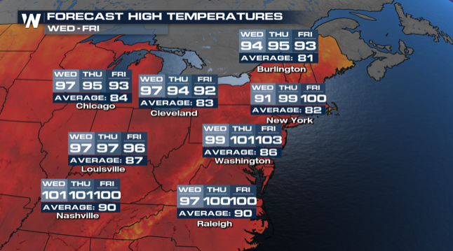
Seven Day Temperature Outlook - Manchester NH & Southern New England

Current Northeast Radar

Expected Temperature Range


Health - The Five Day Allergy & Mosquito Outlook for Southern NH


Rich's Weather Discussion
New Hampshire/North Briefing
Massachusetts/South Briefing

At this moment: 7/13 - 3:50 PM
Notes from Rich:
What is the 'Regular’ Schedule.
Weekdays: Morning updates each day before 8AM, Evening Updates before 7PM.
On Weekends: Perhaps a bit later. I like to sleep in.
Every Thursday morning I post the daily forecast through the weekend.
Upcoming Site Update Schedule Changes:
None
Humidity and dewpoint temps are beginning to tick up this afternoon. Heat Advisories are active across the region for Tuesday/Wednesday. On Tuesday a front will drop south bringing the chance for strong storms, large hail, and isolated thunderstorms. At the moment, the worse of this frontal passage seems to be in northern and central NH. Stay tuned to later forecasts for complete coverage estimates.
Hot and humid weather will build across northern New England on Tuesday, followed by a potentially dangerous severe weather outbreak from late afternoon through the overnight hours. Some storms could become intense, producing damaging winds, large hail, tornadoes, and frequent lightning. Conditions become less humid on Wednesday, although temperatures remain hot with gusty winds. Another cold front arrives Thursday with additional chances for showers and thunderstorms before slightly cooler weather settles in for the weekend.
Check out the enhanced "Todays Weather at a Glance" section above.
Check out todays Weather History. This was the hottest day ever recorded on earth. Guess where?
======
Join us, it costs nothing:
Join over 250 of your fellow weather watchers who get my every Thursday evening 'Weekend Outlook' e-mail blast. This is a free service, with no spam ever (because I manage the list) that arrives in your E mail box every Thursday evening. I also use this list for special warnings, blizzards, hurricanes, severe weather alerts.
You sign up, you control it, quit at any time. In 27+ years I have never given away an email address, and you will never receive any spam because you signed up.
The sign up form is at the bottom of this page.
====
What information can you find on my site, and where is it?
The History Section has a lot of history to share, and I will be sharing video on this page from time to time. Updated every day with new weather history.
Find beach and hiking, and Ski information as well as travel info for the USA in the Travel and Leisure Section.
Find all Tropical Tracking/Hurricane information on the Tropics Page.
Find the current Drought Maps here. Now showing a map for each New England State.
Looking for Radar? Try the Radar Page.
Looking for Weather News from Across the globe, plus more local weather info? Look here.
Note: When you move your cursor over an image, the image fades. Click on the image and that opens a lightbox view that expands the image and allows you to click through all of the images in a section.
====
On this day in history:
On this day in 1930, the first FIFA World Cup kicked off in Uruguay, where France's Lucien Laurent scored the tournament's first-ever goal in a 4-1 win over Mexico. That same afternoon, the U.S. blanked Belgium 3-0. Ninety-six years later, the World Cup semifinals begin tomorrow on American soil.

Latest site updates and additions:
Find the July Almanac Here
Hurricane Season began on June 1st - Details and forecasts can be found here.
06/01 - Find the Mosquito Outlook in the Heath Section.
05/02 - Find the Summer 2026 Outlook for the USA here.
05/01 - The Hampton Beach Report returns! Updated daily.
In the Health Section above, starting April 7, you will find the Allergy Forecasts for Southern NH.
You can find my weather Reading via Weather Underground here: Peterborough, NH Readings
Catch Weather News Headlines and links here.
I have updated Rain/Snowfall totals here.
Drought information updates every Other Thursday evening. Last update: 07/10 - Next Update: 07/31 (or thereabouts)


Weather Summaries and Full Area Forecast Discussions - North (Edited)
Summary - Northern New England - New Hampshire and Maine
Summary:
Hot and humid weather will build across northern New England on Tuesday, followed by a potentially dangerous severe weather outbreak from late afternoon through the overnight hours. Some storms could become intense, producing damaging winds, large hail, tornadoes, and frequent lightning. Conditions become less humid on Wednesday, although temperatures remain hot with gusty winds. Another cold front arrives Thursday with additional chances for showers and thunderstorms before slightly cooler weather settles in for the weekend.
Key Messages:
- Hot and humid Tuesday with a Heat Advisory in effect for much of northern New England.
- Severe weather, potentially significant, is likely from late afternoon into the early overnight hours on Tuesday. The highest threat for severe weather is expected from 6 PM Tuesday evening through 2 AM Wednesday morning. Damaging winds, large hail, tornadoes, and frequent lightning are all possible.
- Humidity decreases Wednesday while hot conditions continue with breezy winds.
- A cold front crosses Thursday, bringing chances for showers and thunderstorms along with a slight cooling trend into the weekend.
What has changed since the last Forecast Update?
The Heat Advisory for Tuesday has been expanded to include coastal Cumberland County. Confidence continues to increase that severe thunderstorms will develop Tuesday evening into Tuesday night.
What this means for you:
Tuesday will be a day to pay close attention to the weather. Dangerous heat during the day will be followed by a higher than normal risk for severe thunderstorms during the evening and overnight, when many people may be asleep. Have multiple ways to receive weather warnings, especially if you are camping or spending time outdoors. Conditions improve Wednesday as humidity drops, but it will remain hot and breezy. Another round of showers and thunderstorms is possible Thursday before more comfortable temperatures arrive for the weekend.
Click the Open/Close Button to Display the Full Edited Area Forecast Discussion
**Area Forecast Discussion,
National Weather Service Gray ME**
**232 PM EDT Monday Jul 13 2026**
**What Has Changed**
The Heat Advisory for Tuesday has been expanded to include coastal Cumberland County. Confidence continues to increase that severe thunderstorms will develop Tuesday evening into Tuesday night.
**Key Messages**
1. Hot and humid Tuesday with a Heat Advisory in effect for much of northern New England.
2. Severe weather, potentially significant, is likely from late afternoon into the early overnight hours on Tuesday. The highest threat for severe weather is expected from 6 PM Tuesday evening through 2 AM Wednesday morning. Damaging winds, large hail, tornadoes, and frequent lightning are all possible.
3. Humidity decreases Wednesday while hot conditions continue with breezy winds.
4. A cold front crosses Thursday, bringing chances for showers and thunderstorms along with a slight cooling trend into the weekend.
**Discussion**
**Key Message 1 Description**
Weather analysis shows an upper level disturbance, known as a 500 millibar shortwave, moving across Quebec this afternoon. Satellite and radar imagery show an area of increasing clouds and light showers associated with this feature. It will move across northern New England later today, bringing mostly light showers to the northern half of New Hampshire and western Maine through this afternoon and evening.
A brief thunderstorm cannot be ruled out, but the chance remains very low based on forecast atmospheric conditions. The showers should move east and end around midnight, leaving dry and mild weather overnight.
Forecasters will also monitor another area of showers or thunderstorms that could move south out of Canada late tonight into early Tuesday morning. Most forecast guidance indicates these storms will weaken before reaching the international border, although a few could survive into northern New Hampshire or northwestern Maine.
For Tuesday, warmer and much more humid air will continue moving into the region ahead of an approaching cold front. High temperatures are expected to reach the 90s across much of northern New England. Dew points are forecast to rise into the middle and upper 60s, making it feel like the middle 90s to around 100 degrees. Those conditions support the ongoing Heat Advisory, which has now been expanded to include Coastal Cumberland County.
**Key Message 2 Description**
Attention now turns to the growing threat for severe thunderstorms Tuesday afternoon and evening, which could become significant.
The Storm Prediction Center has placed northern New Hampshire and the western mountains of Maine under an Enhanced Risk, Level 3 out of 5. Central New Hampshire and interior Maine are under a Slight Risk, Level 2 out of 5, while coastal Maine and southern New Hampshire remain under a Marginal Risk, Level 1 out of 5.
Another strong upper level disturbance will move across Quebec Tuesday afternoon and evening while its associated cold front approaches from the northwest. As the atmosphere becomes increasingly unstable, strengthening winds at higher levels of the atmosphere and rising air motion will create favorable conditions for severe thunderstorm development.
Forecast models continue to indicate very favorable ingredients for severe weather, including strong wind shear, which is the change in wind speed and direction with height, and abundant atmospheric instability. These conditions support the potential for widespread damaging wind gusts, some possibly exceeding 75 miles per hour. The atmosphere will also be capable of producing hail as large as golf balls or even larger. Wind patterns near the ground are also favorable for tornado development, especially with individual storms before they organize into a larger line.
Storms are expected to begin developing across southern Quebec during the late afternoon before rapidly strengthening as they move into northern New Hampshire and northwestern Maine between 6 PM and 8 PM. The storms will then continue south through the evening and into the overnight hours.
A few isolated storms could develop as early as 4 PM to 6 PM before the main line arrives. The severe weather threat should gradually decrease after 2 AM Wednesday, although a few showers and thunderstorms may linger overnight.
This is not a typical severe weather event for this region. The overnight timing increases the danger because many people may be sleeping when warnings are issued. Everyone should have multiple reliable ways to receive weather warnings. Campers and those spending time outdoors will be especially vulnerable because strong winds can quickly bring down trees.
**Key Message 3 Description**
The cold front responsible for Tuesday nights severe weather will move offshore Wednesday morning.
Much drier air will arrive, allowing humidity levels to drop noticeably with dew points falling into the 50s. Even with the lower humidity, temperatures will still climb into the upper 80s and lower 90s. Gusty west winds are expected during the afternoon, with gusts reaching 25 to 30 miles per hour.
**Key Message 4 Description**
An overall trough, an elongated area of lower atmospheric pressure, will remain over the Northeast through the end of the week.
Another upper level disturbance will push a cold front through the region Thursday evening. Lower humidity should reduce the amount of atmospheric instability, but enough energy may still develop to support scattered showers and thunderstorms Thursday afternoon and evening. The greatest chance will be across the mountains and areas to the north.
Before the front arrives, hot, dry, and breezy conditions will continue south of the mountains with afternoon highs reaching the upper 80s to lower 90s.
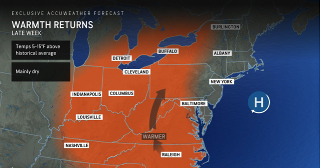
A cooler air mass follows the front, bringing daytime highs mainly in the 70s and 80s from Friday into the weekend. Additional disturbances moving through the upper level trough may bring occasional showers over the weekend, although overall chances remain relatively low, around 20 to 40 percent.
Weather Summaries and Full Area Forecast Discussions - South (Edited)
Summary - Southern New England - Massachusetts/Northern CT/Rhode Island
Summary:
Hot and increasingly humid weather is on the way for southern New England after another pleasant day today. A Heat Advisory is in effect from Tuesday morning through Wednesday evening for much of the region, with heat index values expected to reach 100 to 103 degrees in some locations. The hottest conditions will occur Tuesday and Wednesday before cooler air and a more unsettled weather pattern arrive later this week with increasing chances for precipitation.
Key Messages:
- Dry and comfortable conditions continue today.
- Heat and humidity return midweek. Heat Advisories go into effect Tuesday morning through Wednesday evening.
- Periods of unsettled weather are possible later this week as an upper level trough, an area of lower pressure and cooler air high in the atmosphere, moves across the region.
What has changed since the last Forecast Update?
A Heat Advisory has been issued from Tuesday into Wednesday for much of southern New England. Heat index values are likely to reach 100 to 103 degrees in some areas.
What this means for you
Today is the best opportunity to enjoy comfortable summer weather before the heat returns. If you have outdoor plans Tuesday or Wednesday, limit strenuous activity during the hottest part of the day, drink plenty of water, and check on anyone who may be sensitive to the heat. By late week, expect somewhat cooler temperatures along with a greater chance of showers and thunderstorms as a weather disturbance moves into the Northeast.
Click the Open/Close Button to Display the Full Edited Area Forecast Discussion
**Area Forecast Discussion**
National Weather Service Boston/Norton MA
**145 PM EDT Mon Jul 13 2026**
**What Has Changed**
A Heat Advisory has been issued from Tuesday into Wednesday for much of southern New England. Heat index values are likely to reach 100 to 103 degrees in some areas.
**Key Messages**
* Dry and comfortable conditions continue today.
* Heat and humidity return midweek. Heat Advisories go into effect Tuesday morning through Wednesday evening.
* Periods of unsettled weather are possible later this week as an upper level trough, an area of lower pressure and cooler air high in the atmosphere, moves across the region.
**Discussion**
**Key Message 1, Dry and comfortable conditions continue today**
A broad area of high pressure remains over New England today before moving offshore tonight. A weak shortwave trough, a small disturbance in the upper atmosphere, may trigger a few isolated showers across northern and western Massachusetts this afternoon. Any showers that develop will be brief and remain below severe limits. Most locations will stay dry. Winds from the south southwest will help temperatures climb into the middle to upper 80s, with heat index values reaching the upper 80s to lower 90s.
**Key Message 2, Heat and humidity return midweek. Heat Advisories go into effect Tuesday morning through Wednesday evening**
A broad area of high pressure in the middle levels of the atmosphere over the Upper Midwest will expand eastward into New England Tuesday and Wednesday, leading to a significant warming trend.
Temperatures about 5,000 feet above the ground, known as the 850 millibar level, will warm considerably by Tuesday evening. This is a strong indicator that afternoon temperatures at the surface will climb into the middle 90s across much of southern New England both Tuesday and Wednesday.
Persistent southwest winds will also transport very humid air into the region, with dew points approaching 70 degrees. Overnight temperatures Tuesday night will only fall into the middle 70s, with some locations remaining near 80 degrees, providing little overnight relief from the heat.
As a result, Heat Advisories have been issued for most of southern New England, excluding Cape Cod, the Islands, and the eastern slopes of the Berkshires, from Tuesday morning through Wednesday evening.
Although this heat is not expected to be quite as intense as the previous heat wave, it will still pose a significant risk for anyone working or spending extended time outdoors.
**Key Message 3, Periods of unsettled weather possible later this week as an upper level trough pushes over the region**
Forecast guidance continues to show an upper level trough, an elongated area of lower pressure and cooler air aloft, deepening across Quebec later this week. As this system moves closer, cooler air several thousand feet above the ground will spread into southern New England.
This should lower afternoon temperatures into the lower to middle 80s by Friday, although the Connecticut River Valley may still reach the upper 80s.
Several weak upper level disturbances are expected to rotate through the trough, bringing increasing chances for precipitation and more unsettled weather from late this week into the upcoming weekend.
Countdown to Autumn

Autumn Begins on: September 23, 2026 at 2:05 AM EDT
92Days18Hours28Mins13Secs
Five Day Daily Temperature Run - Peterborough, NH
Updated Every Morning
Normal Daily Averages
High Temperature: 79 Degrees - Low Temperature: 56 Degrees
(Tip: Place your cursor over the bar below to see the number)


Weather News/Headlines of Interest

Severe risk to sweep across New England fueled by dangerous heat
Dangerous heat to reach from Salt Lake City to Minneapolis, Philadelphia
Dangerous flood threat targets millions across Texas, including Hill Country, and the Gulf Coast
Magnitude 6.3 earthquake strikes west of Loyalty Islands in latest Pacific Ring of Fire quake
El Nino surges toward 'monster' territory, signaling an active winter for East and West coasts
UK heatwave to intensify in second week as wildfires burn across UK
Hikers Are Reminded to Be Aware, Prepared, and Responsible When Heading out in New Hampshire


RichLefko.Com Sponsors
Please patronize those running ads below - They are the lifeblood of RichLefko.com
Click on the company logo to go directly to their site.
Anrik Irrigation
My Longest Sponsor, I am pleased to present Anrik Irrigation. Anrik Irrigation is a full service lawn sprinkler company. They perform a variety of services, installation, maintenance, fall blow-out, spring start-ups, and offer a great brand of deicer for winter. Ask me!!

Freedom Cad
Freedom Cad offers PCB Design Services, Enginerring Services, and other value added services. They are headquartered in Nashua NH.
Freedom Cad Offers: PCB Design Services, Engineering Services, and Value Added Services.
Download their free eBook, The Printed Designer`s Guide to Executing Complex PCBs.
Download Now

Patton Energy - Keene NH
Discover the Patten Energy Difference
At Patten Energy, our philosophy is simple. We believe that bigger is not always better! We are neighbors serving neighbors - where you will always be referred to by name, never as just another account number. We are dedicated to maintaining the personal touch and quality care only a family run business can provide.
I use Patten Energy, and I heartily endorse them.

Dan`s Tutorials
If you own ANY Apple products, I can highly recommend Dan's Tutorials. I am a visual learner and Dan's vidoes walk you through each and every option whether you are using an iPad/iOS, or a Mac/Mac OS, or an Apple Watch. Dan has you covered on ALL Apple devices.

All Tree
Need tree removal service? Snow Plowing?
I use ALL TREE, based in Jaffrey NH.
Fully Insured - Free Estimates
Quality Professional Tree Care with over 20 years of Experience
Fair pricing, and these guys do a great job.
Click the logo to go to the website.
Please contact Roy Watson at: 603-782-6659


Flood Watches are active!
There are active Flood Watches for Southern NH, especially here in SW NH.
Click the button below to see the Flood Watches.
This box will close in 15 seconds.
Click the X above to dismiss this box if you do not want to wait.
Sign up for my every Thursday Evening
'Weekend Outlook' Newsletter
Scroll to the bottom of this page or hit the button below
You will get only one e-mail each week from me. Subscribe, quit any time. YOU manage it.
No Spam, No ads, no junk, ever.
This box will close in 15 seconds, or use the close button at the top.
Subscribe to my Alerts
Subscribe to my Weather Alerts and get the Every Thursday Evening 'Weeked Outlook'
E-mail.
You manage your subscription.
Cancel whenever you want.
BTW, we do not sell, trade, give away, post, whisper, dream about, tattoo, print or share your e-mail addresses with anyone...EVER!
When you subscribe, your address goes directly to me, not some online service.
Subscribe once and get all e-mails and warnings!
Yes, you can subscribe to multiple addresses, home, office etc.
Zero cost - No ads-No tracking
Just the Weather - No Hype
Add a Richlefko.com app icon to iphone/ipad
Add a RichLefko.com icon to your iPhone or iPad. It is easy. If you find yourself frequently visiting a website or using a web app on your iPhone or iPad, it is very easy to add a shortcut icon directly on your Home screen using Safari that you can quickly tap to launch the site. This is how: How to add a website tile to your iphone or iPad home screen
Proud member of the National Weather Service Skywarn Program